


 Dolmen
Description
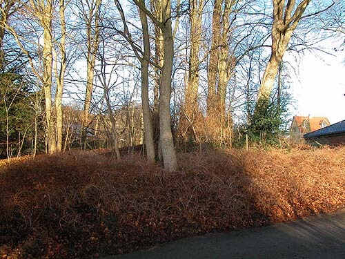
The Årslev cairn on Silkeborgvej in Aarhus
The Årslev dolmen is one of the few remaining stone dolmens in the Aarhus area that has not been removed in connection with the advance of agriculture and urbanization. The reason is probably that the dolmen – or rather the dolmen chamber – was voluntarily listed as a protected site as early as 1870. Due to the surrounding buildings and, not least, the excavation of the terrain in connection with the construction of Silkeborgvej, from which a staircase leads up to the cairn, it is difficult to imagine the original landscape in which the cairn was built approximately 5,500 years ago.

At the car company "Dyssehøj" – about 700 m further east along Silkeborgvej – there was a similar stone dolmen until around 1880. Another large stone grave was located in the forest directly opposite the Årslev dolmen. A group of large lime trees on a slight elevation now marks the spot where the slightly younger stone coffin from the end of the Neolithic period, excavated in 1822 and now dismantled, was located.

When the Årslev dolmen was built by the so-called "funnel beaker culture," the depression where Brabrand Lake and the now restored Årslev Engsø are located was a saltwater fjord arm from the Kattegat. At the mouth to the east, where the Aarhus River now drains the lakes, the fjord was quite narrow.

Subsequent land uplift and silting at the outlet subsequently transformed the fjord into a large freshwater lake. The now meandering Voldbæk stream in the depression immediately east of the Årslev dolmen, which in the Middle Ages and historical times was dammed for use by the Årslev watermill, was in the Stone Age a small north-facing inlet from the large, shallow Brabrand Fjord.

It is only in recent centuries that the town has spread to become the continuous settlement we see today. The map of the Royal Danish Academy of Sciences and Letters from 1787 shows a landscape quite different from today's, with large, fertile meadows along the lake on the old fjord bed. Broadly speaking, thanks to the abundant resources along the fjord, the lake, the nearby sea, and the surrounding forests and farmland, people have almost always lived in the area since the last ice age.

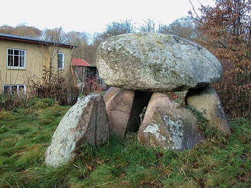
The remaining burial chamber is only the central part of what was originally an almost completely enclosed burial site, of which only the top of the large capstone above the chamber and the south-facing opening from the passageway were originally visible. Of the chamber passage, only one of the presumably two pairs of supporting stones has been preserved, and the capstones above the passage have also disappeared.

The capstone above the chamber, which was probably put in place using the now-disappeared mound around the chamber as a ramp, may have been split so that the flat side could form the ceiling of the chamber.

The capstone is supported by four of the original five supporting stones – one is missing on the north side, but this provides a good opportunity to look into the burial chamber itself.

We know of no finds or excavations from the Årslev dolmen, but from the slightly younger "neighboring grave" on the other side of Silkeborgvej, which Colonel Høegh Guldberg excavated in 1822, finds of flint knives, flint arrows and seals, ceramics, and, not least, more than 60 amber beads. This clearly shows the function of the megalithic tombs as communal graves from the Neolithic period and their central role as gathering places for religion and worship for the Funnel Beaker Culture, which, due to their farming practices, were one of the first settled cultural groups we know of. Subsequently, the type of grave changed. In the Bronze Age (1700-500 BC), mainly peat-built burial mounds were constructed, and several of these can still be seen in the forest areas north and south of the Årslev dolmen.


Video

Access
- Dyssen ligger i Årslev, ca. 1 km. øst for Årslev kirke, ved det tidligere hotel ”Tre Ege” (nu alderdomshjem) lige op ad nordsiden af Silkeborgvej.
- Parker hensynsfuldt på parkeringspladsen lige vest for benzintanken langs nordsiden af Silkeborgvej.
- En trappe i den nordre vejskråning fører op til dyssen.
- Fra modsatte vejside fører en sti fra en mindre trappe ud til Silkeborgvej skråt overfor førstnævnte, frem til stedet hvor ”nabodyssen” har ligget.
Faciliteter
- Informationsskilt ved dyssen.
- Afstand til fortidsminde: ca. 75 m.
Særlige forhold
- Vis hensyn til nærliggende private bebyggelser.
- Kun adgang via trappen fra Silkeborgvej til det lille indhegnede område omkring dyssen.
- Ved færdsel i nærliggende skov skal stierne følges.
Directions


Aerial Photo
Remember when visiting
- Keep dogs on a leash — avoid contact with grazing animals
- Avoid wear damage and always follow signage
- Never dig at or near ancient monuments
- Be aware of fire hazards — never use open flames
- Contact the supervisory authority in case of damage or problems
Administration
- Ownership
- Privately owned
- Created
- 2020
- Last edited
- 02-2026
- Inspection and damage
- The Danish Agency for Cultural Heritage
- Care, signage and 100m zone
- Aarhus Municipality
- Protection no.
- 2414-5
- Site no.
- 150307-12
Find the monument with GPS
- GPS:
-
Longitude: 10.085900Latitude: 56.152986
Vidste du...
Danevirke er Nordeuropas største forsvarsværk, et over 30 km langt voldsystem som blev udbygget fra ca. 500 til 1200 e.Kr.
Vikingetid