


 Dolmen
Description
Balle Dyssen – an intact round barrow in a mound
In the field just north of Balle town lies Djursland's only completely intact burial chamber in a mound.

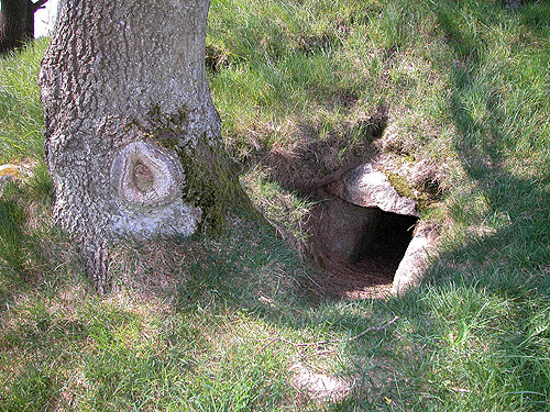
From the asphalt road, where the footpath to the burial mound leads across the field, the mound looks like any ordinary burial mound. But when you reach the mound, you can see a narrow stone opening on the east side by the oak tree that marks the mound.

If you remember to bring a flashlight—and have the courage to crawl through the 2-meter-long and quite narrow passage—you can experience the atmosphere in the completely enclosed and sealed burial chamber that the mound encloses. The mound was originally surrounded and marked with "curbstones." These are no longer visible and have either been removed or hidden by soil that has slid down from the mound.
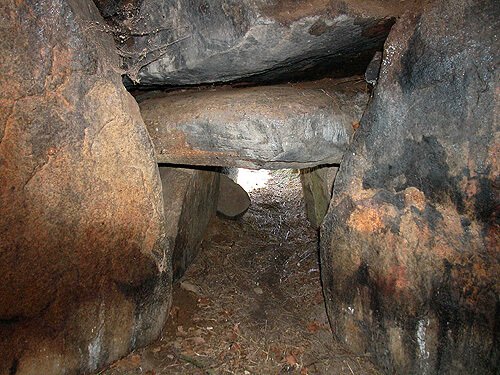
From inside the dolmen, daylight is only faintly visible through the passageway, but once your eyes have adjusted to the darkness, you can see several interesting architectural details.
In the ceiling at the transition between the passageway and the burial chamber lies a so-called "key stone."

It distributes the pressure from the enormous 10-15 ton capstone above the chamber onto the supporting stones around the passageway opening of the burial chamber. The narrow, low-ceilinged passageway is constructed of 2 x 2 supporting stones and covered by 2 capstones, and it widens considerably to almost full standing height (1.7 m) in the chamber. The burial chamber measures 2 x 1.8 m, and between its five supporting stones, a well-preserved dry stone wall of flat, stacked stones can be seen in several places, preventing soil from the surrounding mound from sliding into the burial chamber. The supporting stones face the chamber with their flat sides, forming a pentagonal room.

The dolmen is a large round dolmen and dates back to around 3,400 BC. No archaeological excavations have been carried out in it, and unfortunately we do not know of any finds from it, or traces of the many people who have probably been buried in it over time. The dolmen was listed as early as 1887, which is marked by the preservation stone on the mound.

When the cairn was in use, the surrounding landscape looked quite different. Today, the small Hoed Å river flows towards the Kattegat in the town boundary about 100 m southwest of the cairn. In the Stone Age, the low-lying area was a narrow, approx. 5 km long fjord arm from the Kattegat, which has since disappeared due to land uplift and drainage, leaving today's stream. The round dolmen is now located about 12 meters above sea level. When the Stone Age sea reached its greatest extent around 5,000 BC, it was almost 7 m higher than today.
Access
- I Trustrup på vej 21: Tåstrup-Ebeltoft, drejes sydover ad Ballevej imod Balle.
- Passér Lykkesholm Gods og fortsæt yderligere ca. 1,2 km og parker i vejsiden.
- Dyssen / højen ligger frit på marken ca. 400 m før Balle by.
- Følg trampestien fra markeringspælen i vejkanten over marken til højen.
Faciliteter
Informationsskilt ved højens østside.
Afstand til fortidsminde
50 m.
Særlige forhold
- Vis hensyn til markafgrøder.
- Følg den markerede trampesti over marken.
- Husk en lygte hvis du kravler ind i gravkammeret. OBS: Gangen til kammeret er meget smal.
Directions
Related literature

348 oldtidsminder i Jylland
Henning Dehn-Nielsen

Guide til Danske fortidsminder
Carsten Henrik Bang

Vejviser til Danmarks Oldtid
Ingrid Falktoft Andersen

Danmarkshistorien bind 1-2, Stenalderen
-

På tur i Djurslands fortid
Karsten Kristiansen

Danmarks Oldtid, Stenalderen
Johannes Brøndsted

Stendysser - Arkitektur og funktion
Palle Eriksen & Niels H. Andersen
Aerial Photo
Remember when visiting
- Keep dogs on a leash — avoid contact with grazing animals
- Avoid wear damage and always follow signage
- Never dig at or near ancient monuments
- Be aware of fire hazards — never use open flames
- Contact the supervisory authority in case of damage or problems
Administration
- Ownership
- Privately owned
- Created
- 2020
- Last edited
- 02-2026
- Inspection and damage
- The Danish Agency for Cultural Heritage
- Care, signage and 100m zone
- Norddjurs Municipality
- Protection no.
- 2218-40
- Site no.
- 140205-1
Find the monument with GPS
- GPS:
-
Longitude: 10.809208Latitude: 56.322310
- UTM system:
- E 611889 N 6243423

Vidste du...

I jernalderen ofrede man hele hære af besejrede fjenders våben i moser. Ved Illerup Ådal er fundet våben fra over 1.000 krigere.
JernalderLæs mere: