
 Passage grave
Description
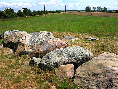
Måneshøj and Svinø Østerhøj are two extremely interesting megalithic tombs from the Neolithic period on the Svinø peninsula. Both are part of a publicly accessible trail system established in collaboration with "Landbrugets Naturplan for Køng Sogn" (Agriculture's Nature Plan for Køng Parish). This is an association of 46 landowners whose aim is to establish a 60 km long trail system in the area and to introduce a number of environmentally friendly farming practices.

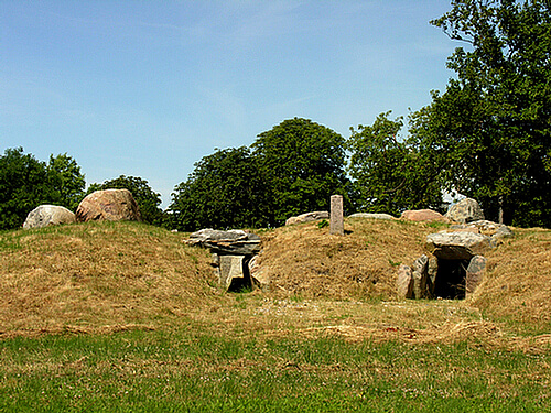
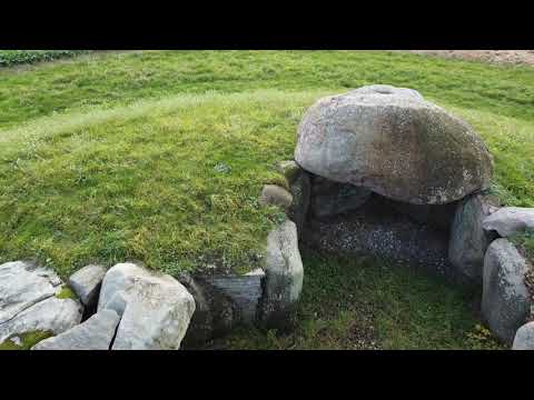
Both Måneshøj and Østerhøj have been thoroughly restored by the National Museum. Måneshøj was restored in 2004 and, unlike Østerhøj, has an open floor plan. This means that the mound that originally covered the megalithic tomb is missing, making the floor plan with its supporting and covering stones easily accessible and clearly visible. But Måneshøj is special in that it is one of the relatively few well-preserved double megalithic tombs we have in Denmark.

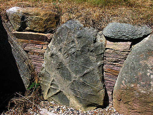
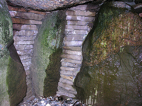
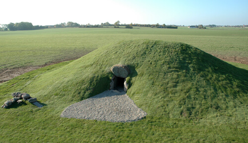
In Østerhøj there is a large burial chamber with an adjoining passage, but in Måneshøj there are two connected burial chambers, each with its own southeast-facing chamber passage. The two burial chambers are separated by a single upright stone, around which a so-called dry stone wall of flat stones has been built. The two burial chambers are symmetrical and aligned with each other, oriented northeast-southwest in the remains of the mound that originally completely sealed the structure. As the burial chambers share a supporting stone, they must be presumed to have been built at the same time around 3,200 BC.

It is not known for certain why Måneshøj has two burial chambers. One can imagine that the burial chambers represent a gender division into male and female graves, or that the burials in the two chambers reflect territorial or family relationships in relation to the tribes or families of the area.

Måneshøj was excavated by the National Museum in 1908 after the owner had begun digging in the mound. At that time, the excavation was carried out by opening the grave from above, which explains the current open floor plan of the megalithic tomb. During the excavation, skeletal remains from the burials of women, men, and children were found in both burial chambers, which casts doubt on the assumption that the burials in the two chambers were separated by gender. The National Museum has more than 300 different artifacts from the excavation. There were many shards from the beautifully decorated clay pots that the so-called "Funnel Beaker Culture" sacrificed or gave as grave gifts to the deceased. One particularly beautiful pot is a fantastic face pot with two eyes and eyebrows - see a beautiful photo of the pot HERE. Several beautiful, polished flint axes and flint tools were also found during the excavation.

The Funnel Beaker Culture (3,900-1,700 BC) is named after its clay pots with funnel-shaped mouths. Based on the shape and ornamentation of the clay pots, a fairly accurate sequence of development has been established for the styles of the culture, which is used to date the finds. The ornamentation on the face pot from Måneshøj, for example, belongs to the so-called Bundsø style from around 3,000 BC.

Although Måneshøj has been excavated, most of the stones from the megalithic tomb are still in place. The stone settings provide a good insight into the construction of the tomb itself, which is why the megalithic tomb was also listed in 1940 under the first Nature Conservation Act of 1937. The listing protects the megalithic tomb from abuse and destruction, but not from the deterioration of nature itself.

Today, these protected ancient monuments often lie as small isolated "islands" in cultivated fields, where they are often forgotten. They are slowly obscured by trees and scrub and, in the worst case, become home to foxes and badgers, whose destructive burrowing undermines, for example, the supporting stones of the megalithic tombs. Preservation without ongoing supervision and possible maintenance is therefore necessary to maintain the standard and value of the ancient monuments.

Vordingborg Municipality therefore maintains the Måneshøj megalithic tomb on an ongoing basis, along with several other ancient monuments of interest in the municipality. Natural decay was also the basis for the National Museum's restoration in 2004, when the supporting stones in the burial chambers were re-erected and the gaps filled with red sandstone tiles. At the same time, the ton-heavy capstones above the chambers were replaced and secured. Exploratory excavations in connection with the restoration also determined that the megalithic tomb was built on a former field some 5,200 years ago. The megalithic tomb seals off a small piece of the surface of that time, and when the soil was cleared, clear traces of the primitive plow of that time appeared—the so-called ard, which, unlike today's plow, did not turn the soil but simply furrowed it.

Another important observation during the restoration was a stone-lined excavation in the mound behind the megalithic tomb's burial chambers. It is believed to have formed the foundation for a lifting beam that was used to pull the large capstones up onto the mound and on to their final location as the ceiling of the burial chambers. Other large stone graves also feature earthen ramps connected to the surrounding stabilizing mound, which were part of the same process.


Read more about the sights at Avnø and Svinø HERE
Below you can also see P. B. Jeppesen's beautiful drone film from the area (YouTube).
Video
Access
- At Køng on highway 22 Næstved - Vordingborg, turn towards Svinø.
- Follow Svinøvej to Svinø town and turn right onto Dybesøvejen.
- Follow the road for approx. 950 m and turn right onto Svinøvestervej (signposted to historical monument).
- Park at the first gravel road on the right-hand side approx. 200 m ahead and follow the gravel road on foot approx. 100 m to the sign and the stairway leading to the megalithic tomb.
Facilities
- Information sign and brochure box as well as table/benches by the footpath/ancient monument.
- Distance to ancient monument: 280 m.
Special
- Follow the footpath and limit traffic to the mound and its surroundings.
- Park considerately so as not to obstruct traffic on the gravel road.
Directions


Aerial Photo
Remember when visiting
- Keep dogs on a leash — avoid contact with grazing animals
- Avoid wear damage and always follow signage
- Never dig at or near ancient monuments
- Be aware of fire hazards — never use open flames
- Contact the supervisory authority in case of damage or problems
Administration
- Ownership
- Privately owned
- Created
- 2020
- Last edited
- 02-2026
- Inspection and damage
- The Danish Agency for Cultural Heritage
- Care, signage and 100m zone
- Vordingborg Municipality
- Protection no.
- 4025-1
- Site no.
- 050404-1
Find the monument with GPS
- GPS:
-
Longitude: 11.740710Latitude: 55.114845
- UTM system:
- E 674795 N 6111002
Vidste du...
Gravhøjene langs "Hærvejen" i Jylland danner en markant kæde, der kan følges i hundredvis af kilometer.
Gravhøje